Useful
Information
Useful information
Sounio - Lavreotiki
Lagonisi, Saronida, Sounio, Lavrio, Thoriko, Agios Konstantinos, Anavyssos
A large route that requires the use of a private car and of course, can last more than one day if the visitor wishes. It is a road trip to the southern beaches of Attica, the historical sites of Sounio and Thoriko, the Lavreotiki Geopark, and the National Park of Sounio. The coastal area is a favorite destination for relaxation and recreation for the Athenians, while the overall route is filled with monuments, churches, archaeological sites, beaches, etc. The National Park and the Geopark significantly enrich the identity of the route.
The route includes the following landmarks, and their sequence indicates the direction of the journey.
Note: The orientation and safety of the walker/visitor is their sole responsibility. The present description, the related tracks (gpx) and the other informative material are simply a guide and do not in any way replace the personal responsibility of the visitor.
Main landmarks:
- Lagonisi
- Saronida
- Mavro Lithari Beach
- Alikes Anavyssos
- Anavyssos Beach
- Palaia Fokaia
- Thymari Beach
- Akra Kataphygi
- Charakas Beach
- Artzentas Isle (Artsida or Gaidaros)
- Legrena Beach
- Patroklos Islet
- Sounio
- Archaeological Site of Sounio
- Kato Sounio
- Asimaki Beach
- Limani Passa Beach
- Kato Poseidonia
- Lavrio
- Archaeological Museum of Lavrion
- Mineralogical Museum of Lavrion
- Lavrion Technological and Cultural Park
- Archaeological Site of Thoriko
- Sounio National Park
- Agios Konstantinos
- Mineralogical Museum of Kamariza Agios Konstantinos
- Egkilo Chaos (Kitsos)
- Lavreotiki Geopark
- Anavyssos
- Saronida
The journey starts from the beautiful Lagonisi, located approximately 30 kilometers southeast of Athens. It is a peninsula stretching 900 meters along the eastern shores of the Saronic Gulf. Here, you will find large hotel facilities, organized and free beaches, primary and vacation residences, and, of course, interesting restaurants serving fresh fish.
Heading southward along the Athenian coastline, you will arrive at the picturesque seaside town of Saronida. Its name is derived from the Saronic Gulf, which the town proudly overlooks. Saronida is a popular tourist destination, boasting a long, sandy beach and an abundance of summer residences. Stretching from Lagoni to the mountainous slopes of Lavreotiko Olympus and extending to Anavyssos, Saronida’s topography resembles a natural balcony overlooking the Attica region. Saronida stands out for its modern urban layout, accessible beaches, and historical charm. Its remnants of the past, known as “polyvoleia” carry memories of bygone eras. The 3.5-kilometer seaside path, snaking along the stunning Saronic Gulf, offers a unique experience. Constructed with a blend of earth, stone, cement, rock, and granite, this path invites leisurely strolls and breathtaking views.
Venturing south and east of Saronida, you will reach the region of Anavyssos, which is the next stop. Anavyssos Beach, situated in front of the salt flats, is renowned among surfers for its ideal waves. A defining feature of Anavyssos is the extensive area once occupied by salt flats. The Anavyssos Salt Flats Coastal Wetland covers an area of approximately 586 acres. The Athinon – Souniou Avenue separates the wetland from the coastal zone. This region was once a source of Greece’s finest salt. As early as 1520, cartographers documented the salt production methods employed here. Initially, rudimentary techniques were used. Later, canals were constructed to channel winter water into the pits and reservoirs, known as “thermastres” and “trophoi,” transforming it into large, white salt crystals during the summer months. The arrival of refugees from Asia Minor following the Smyrna catastrophe brought their expertise in salt production, contributing to the flourishing of Anavyssos Salt Flats. However, by 1968, salt production ceased, leaving behind a legacy of industry and ingenuity. Today, the wetland functions as a natural rainwater catchment basin, experiencing seasonal or ephemeral flooding. Since 2018, construction, landfilling, disruptive activities, and any actions that degrade its ecological status have been prohibited.
Along the Anavyssos-Sounio road, we encounter Palaia Phokaia, another coastal settlement in East Attica. Established by Greek refugees from the ancient city of Phokaia in Asia Minor, Palaia Phokaia bears witness to the resilience and adaptability of its inhabitants. The Phocaeans, renowned seafarers and traders, were uprooted from their homeland, first in 1914 and later in 1922, with the majority settling in this region. The Phocaean families, alongside the indigenous Sarakatsani people, forged a new homeland in Palaia Phokaia. Over time, others were drawn to the area, acquiring land and building homes. They embraced the region and contributed to its development, giving rise to settlements like Thimari, Katafigi, the ATE Agricultural Bank Settlement, and the Katafigi Bay. Palaia Phokaia’s allure lies in its captivating coastline, the Poseidon Temple, the Pyrgaki with the ruins of a medieval tower, the stunning natural landscape, the hiking trail from the beach to Prophet Elias in Sounio, the picturesque harbor with the small theater, and in the fresh seafood served at the seaside taverns. These are just a few of the gems that await you in Palaia Phokaia.
One of the most beautiful areas in Palaea Fokia is the settlement of Thimari, named after its slopes covered in thyme. The unique view of the Saronic Gulf from its slopes, the greenery, and the magnificent beaches invite you to visit. At the northern end of Thimari Beach, there is a tiny rocky cove that is not visible from the road. It has fine white pebbles, sand and turquoise waters, making it small and quiet haven, ideal for relaxation, picnics, and swimming.
On the Thimari – Sounio road you will encounter Cape Kataphygi (Akra Kataphygi) overlooking the islet of Patroklos. Patroklos, also known as Gaidouronisi (meaning Donkey Island in Greek), is a rocky mass in the Saronic Gulf, covering an area of 2,800 acres, with its highest point rising to an altitude of 240 meters. It is located near the coast, at a distance of 850 meters. Patroklos islet is mentioned by Pausanias and has never been inhabited over the centuries, despite its proximity to the coast. Contrary to common misconception, the island’s name is not related to the famous companion of Achilles from the “Iliad” but rather to the naval commander Patroklos, who led the Egyptian fleet in the Hellenistic era. The island has been under protection since 1982, and in 1998, it was officially declared an archaeological site.
A few kilometers away you will reach Cape Sounion, also known as Cape Colonna or Kavokolones. It is located at the southernmost tip of the Attica region and is one of the most important archaeological sites in Greece. Its coastlines are rocky and steep, rising almost vertically from the sea to a significant height, forming two small coves at its base. Sounion has been renowned since the Homeric era. Homer refers to it as the “Sacred Sounion”. During the Archaic period, the sanctuary of Sounion developed, as evidenced by the colossal statues that were erected there. Three of these statues were discovered, and they are currently displayed at the National Archaeological Museum. During that period, it appears that the Temple of Athena at Sounio was also constructed on a lower neighboring hill. The first Temple of Poseidon made of marble was built at the beginning of the 5th century but was destroyed by the Persians before its completion. In 444 BC, the Athenians built the newer temple of Poseidon, the ruins of which we admire today. It is situated above the sea at a height of almost 60 meters. Constructed during the same period as the Parthenon, in the Golden Age of Pericles, it was not merely a place of worship for the god of the sea. In honor of Poseidon, an imposing statue, standing over 6 meters tall, dominated the interior of the temple. The prominent location above the sea on the southeastern tip of Attica made the temple a landmark for sailors indicating proximity to Piraeus. The design of the temple is a typical hexastyle, meaning it had a front porch with six columns. Only a few columns of the Temple of Poseidon survive to this day, but at the time, it would have closely resembled the contemporary and well-preserved Temple of Hephaestus below Acropolis.
During the 9th year of the Peloponnesian War, Sounio was fortified to protect the vital shipping lanes that supplied Athens with food. Its imposing walls, sections of which still stand to this day, measured 3.5 meters thick and encircled the site with a circumference of 500 meters. Every 20 meters, the wall was reinforced with protective square towers. Amidst the ruins of Sounion, one can still admire the remnants of the ancient port that once sheltered ships under the watchful gaze of Poseidon. The site also boasts the grand Ionic temple of Athena, as well as a smaller Doric temple. Built in 470 BC, the Ionic temple replaced an earlier structure from the 6th century. From this privileged vantage point, with views stretching from the coastline of neighboring islands to the mountains of the Peloponnese, visitors can witness one of the most breathtaking sunsets.
Continuing along the coastal road, after admiring and passing through the beaches of Tratolimano, Kavatza, Kato Sounio, Asimaki, and Limani Passa, we arrive at Posidonia, the capital of the ancient municipality of Sounio. During the antiquity, Posidonia was a thriving settlement. Today, the remains of the ancient agora of the municipality can be seen at the intersection of Poseidonos and Agios Stylianou streets. Scattered throughout the area, and on ” Michalis Mountain ” to the northwest of Posidonia, are numerous other antiquities. Along the shores of Pasa Bay, pillboxes from the German Occupation stand as reminders of a more recent chapter in history. The area holds a significant appeal for both locals and tourists.
This journey will takes you next to Lavrio, also known as the Lavrion Works during the 19th century. This port town, located in the southeastern part of Attica and the seat of the Lavreotiki Municipality, is renowned for its silver mining history. Since classical antiquity, silver mining had been one of the primary sources of income for the city-state of Athens, used to produce coins known as “Lavriotic owls” and fund the Athenian fleet. The name Lavrion itself derives from the word “laura”,( meaning narrow passage or mining tunnel). The ancient mining method involved digging tunnels and shafts. Tunnels, wells, water tanks, furnaces, traces of dwellings, hollows, and other installations can still be seen in dozens of locations across Lavreotiki. The areas of Sounio and Thoriko are believed to be among the oldest industrial cities in Europe.
In recent times, Lavrio has flourished as an industrial town. The region experienced rapid development after 1864, and the new town of Lavrio gradually began to take shape. Many Greek workers were drawn to the area, originating not only from the mainland but also from the Cyclades islands, Crete, Lakonia, Euboea, Boeotia, Phocis. Also, in Vavrio came many foreign workers from Malta. The population of Lavrio surpassed the 10,000 inhabitants at the beginning of the 20th century. Following the Asia Minor Catastrophe of 1922-1924, many refugees from Asia Minor and Thrace settled in Lavrio and the broader Lavreotiki region. After the refugees settled, the sectors of agriculture, fishing, and trade flourished. However, following the definitive closure of the mines (around 1980), the area entered a period of economic crisis and high unemployment.
The modern town of Lavrio, built entirely from 1865 onwards according to a well-planned urban layout, is adorned with large squares, groves, open spaces, and a multitude of significant neoclassical buildings. The town’s churches are also noteworthy, as are the restored historical industrial buildings that now primarily house cultural activities. A part of the town has been designated as a traditional settlement.
This journey continues towards the Archaeological Museum of Lavrio, located at the town’s entrance. It is a single-story building from the 1970s. The exhibition is spread across two halls, the atrium, and the surrounding areas of the atrium. The Archaeological Museum of Lavrio houses findings from the broader area of Lavreotiki (Sounion, Thoriko) and from the mining-metallurgical workshops, showcasing aspects of human life and activity in the region from 5000 BC to the 6th century AD. Notably, the museum features embossed plaques from the frieze of the Temple of Poseidon in Sounion, as well as funerary and votive reliefs from the ancient municipalities of Lavreotiki.
Visiting the Mineralogical Museum of Lavrio is also a great idea. There you will see exhibitions relating to Lavrio minerals, mines and equipment of the miners who worked in the past. It was founded in 1986 by the Lavreotiki Research Society, which restored the building, a typical example of Lavrio’s industrial architecture of the last century and one of the few remnants of the amazing industrial complex of the ore washeries of the “Hellenic Company”, which unfortunately were demolished during the Greek Junta in 1970.
The Museum is in memory of mineralogist Andreas Kordellas, whose scientific work led to the revival of the ancient mines of Lavrio in modern times. The museum’s collection consists of unique in rarity and beauty minerals of the Lavreotiki land. All minerals are in crystal forms, thus creating impressive sparkles and colors. The museum’s exhibits include various miners’ tools and lead turtles that were intended for trade by the mining and metallurgical industries.
The Technological and Cultural Park of Lavrio is an ideal place for walking. It was founded on the site of the old French Society of Lavrio in 1992, on the initiative of the National (Metsovian) Technical University of Athens (NTUA), aiming to host and promote research as well as business activities. It has a single area of 245 acres, which includes 41 buildings within an area of 25,000 acres. To date, 80 acres of facilities with several buildings have been restored, highlighting the Technological and Cultural Park of Lavrio as a unique monument of industrial archeology and architecture. The park facilities include industrial, laboratory and professional spaces of high aesthetic and architectural value, most of which were built during 1875-1940 . It consists of administrative buildings and facilities, which continued to operate until 1988. The industrial buildings have been reconstructed combining the highlighting of the historical form with modern functionality. Today they house several new and innovative businesses, NTUA laboratories as well as cultural and art institutions. The site was declared as a monument by the Ministry of Culture.
Then there is the Archaeological Site of Thorikos. The area was inhabited from the Neolithic era (about 4500 BC) and without interruption until the 1st century BC. The site of the ancient municipality was on Velatouri hill, at the edge of the modern Thorikos plain, near the sea. Thorikos was one of the 12 settlements, which, according to tradition, participated in the political unification of Athens by Theseus. Due to its proximity to the mines of Lavrio, it was the mining center of the region. The excavations brought to light part of the prehistoric settlement, as well as an extensive part of the historic municipality, i.e. residential quarters, cemeteries, the theater and the so-called “industrial quarter”, together with the ancient mines. It is worth noting that the exploitation of mines in Thorikos dates back to around 3000 BC.
In the Archaeological site of Thorikos you will admire its theater, unique due to its shape, with an oval orchestra. It was built at the end of the 6th century BC. and it is the oldest that has been found so far in Greece. The mines are also of great interest. The ancient city of Thorikos is part of the territory, characterized by the presence of rich ores of lead, silver and copper. The stoa’s architecture, the traces on the walls and the finding from the three underground mines of the Velatouri hill, date mainly to three different periods: Late Neolithic / Early Bronze Age, the second half of the 4th century BC. and the 19th and 20th centuries AD. Mine Number 6 has also demonstrated the exploitation of mineral resources during the Late Roman period, particularly in the 6th and 7th centuries AD.
On the Archaeological site we will also see the core of the ancient settlement of Thorikos, which was located on the western slope of the Velatouri hill. Excavations have revealed the image of a densely populated and thriving city of the 5th and 4th centuries BC, with private houses, arcades and workshops. Here we will also find the monumental vaults and chambers of the Mycenaean period (1600-1100 BC):which gave important data on the mining activities of the mines at that time. Before we leave, we will also admire the Temple of Demeter and Kore, a large marble building in the shape of a double portico and Doric style. It dates back to the 5th century BC. and his identification was based on an inscription found in situ.
As you proceed you will visit the National Park of Sounio, which has a core area of 7500 acres. This specific National Park was founded in 1971 and is the smallest forest in Greece but also unknown to many. To get here, from Lavrio you will follow the signs indicating the village of Agios Konstantinos and then the ones indicating “Chaos” and “Agia Triada”. The route is beautiful, filled with views of the sea, as well as sounds and smells of the countryside. Arriving there you will have many options, such as walking and seeing mining arcades of the last century or enjoying nature’s beauty. This Park also houses the so-called Chaos, the unknown crater in Attica, which has the shape of a heart. Then you will continue your tour to the settlement of Agios Konstantinos so as to visit the Mineralogical – Mining Museum. It is easily distinguished, due to the iron tower of the mining shaft. The Serpieri No 1 ore shaft, is 165 meters deep, it was constructed by the French Lavrio Mining Company in 1880 and was used to extract the ore as well as to transport personnel to the underground mines. It operated until 1973 and is one of the most important monuments of the region. In addition to the hoist tower, you will see the building where the propulsion engine was housed. and now houses the Mineralogical and Mining Museum of Kamariza. One can also see the bridge for loading the ore, as well as parts of the open-air warehouses where the ore was sorted.
As you proceed you can always take a walk in the Lavreotiki Geopark. It is essentially an extensive secure network of geo-routes that indicate specific points of geological, historical, mining, archaeological and environmental interest. Among other things, it includes approximately 1,000 mining arcades and the same number of wells, as well as over 40 geo sites of great scientific value. The Lavreotiki Geopark was officially declared a UNESCO World Geopark in 2023.
After you complete this tour, you will return, through Anavyssos, back to Lagonisi where the tour started, without forgetting of course to visit one of the numerous taverns that you will find along the way and that serve great fresh fish. If you do not have enough time, there are many welcoming accommodations along the entire route, however be sure to have planned ahead.
Lagonisi, Saronida, Sounio, Lavrio, Thoriko, Agios Konstantinos, Anavyssos
A large route that requires the use of a private car and of course, can last more than one day if the visitor wishes. It is a road trip to the southern beaches of Attica, the historical sites of Sounio and Thoriko, the Lavreotiki Geopark, and the National Park of Sounio. The coastal area is a favorite destination for relaxation and recreation for the Athenians, while the overall route is filled with monuments, churches, archaeological sites, beaches, etc. The National Park and the Geopark significantly enrich the identity of the route.
The route includes the following landmarks, and their sequence indicates the direction of the journey.
Note: The orientation and safety of the walker/visitor is their sole responsibility. The present description, the related tracks (gpx) and the other informative material are simply a guide and do not in any way replace the
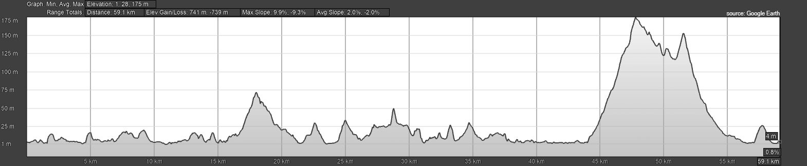
See the elevation profile of the route